BEAUSOLEIL ISLAND, ONTARIO TO PARRY SOUND, ONTARIO

Wednesday, July 29th, 2015

Day 359
Miles Traveled: 43
Total Miles Traveled: 5410


  We said our goodbyes to Jeff and Susan as they headed back to Penetenguishene and we continued our exploration of Georgian Bay.  It is called the 30,000 Islands and they are plentiful.  Some are large, some are small, and some are just one big rock.
larger islands with trees

smaller rock islands


  One thing we discovered about the trees found on Georgian Bay is that they all seem to lean to the east.  We were told this is due to the high winds out of the west during the brutal winter months.
leaning trees
not much wind when picture was taken


  We took a break from cruising at lunchtime and stopped at the famous Henry's Fish Restaurant on Frying Pan Island.  The pan fried pickerel (or walleye in the U.S.) was superb, and so was the butter tart.
Henry's Fish Restaurant


  After the nice lunch break, we finished our cruising day at Parry Sound's Big Sound Marina.  It was a hot day and we were thankful to have electric for air conditioning.  Since we had lunch out, we had dinner in (leftovers), followed by an evening of relaxation. 

PENETENGUISHENE, ONTARIO TO BEAUSOLEIL ISLAND, ONTARIO

Monday, July 27th to Tuesday, July 28th, 2015

Day 357-358
Miles Traveled on Tuesday: 14
Total Miles Traveled: 5367


  Monday we worked on trip planning our Georgian Bay and North Channel segment of The Great Loop.  Jeff and Susan joined us in the afternoon and reviewed the charts offering up great locations to anchor and places to visit.  We all went to dinner for the evening at Flynn's Irish Pub for 1/2 price wing night. 


  Tuesday we left early in hopes of finding an anchorage or dock at Beausoleil Island.  This island is a Canadian National Park with trails, campsites, and small docks located at several different small bays. 

  The cruise to get to around to these bays was beautiful with some open water and some smaller channels.  All around were many islands with the largest being Beausoleil.
beautiful scenery

  Homes and cottages were plentiful on the shorelines and on the islands.  Out from one of the home's docks was a pile of stones in the shape of a man.  Apparently, this is a common site along the Georgian Bay waterway.  It is called an inukshuk.  An inukshuk is a man-made stone landmark which may have been used as a navigation landmark or point of reference marker. 
inukshuk
 

  We first entered Frying Pan Bay, but, all the docks were in use and there were many boats at anchor in the bay.  We moved ahead about one mile and entered Honeymoon Bay.  There we found one dock space available and tied up.
"Seahorse" docked at Honeymoon Bay on Beausoleil Island

  Later Jeff & Susan, now on "Wewena", joined us and rafted off to us at the dock.  After lunch, we hiked Fairy Trail.  This trail was about 1.5 miles long and circled around Fairy Lake.  At several spots along the trail there were pretty views of this lake.
view of Fairy Lake from Fairy Trail on Beausoleil Island

  When we returned from the hike, Dan and Susan took a swim in the bay to cool off.  There was a very nice breeze that also helped with the heat.  We visited for the rest of the afternoon and evening.  There was a beautiful sunset, which we enjoyed as long as we could before the bugs drove us inside.
gorgeous sunset at Beausoleil Island

COLDWATER, ONTARIO TO PENETENGUISHENE, ONTARIO

Sunday, July 26th, 2015

Day 356
Miles Traveled: 23
Total Miles Traveled: 5353


  At shortly before 9:00 am, 
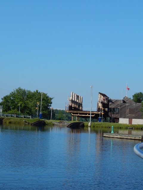
we anxiously left the dock and headed over to the blue line to get in line for our turn on the Big Chute Marine Railway.  We ended up being the first in line.  A Parks Canada worker came over and advised us and the other boats on the blue line that there would be a slight delay due to a mechanical problem.  After about 30 minutes, they called to us over the bull horn and advised we could proceed to the railway.  We were placed behind a smaller boat.
waiting for The Big Chute Marine Railway
  The staff at the marine railway were all very helpful and nice.  They guided us into the slings and lifted "Seahorse out of the water skillfully and efficiently.  Once secured the fun began.
"Seahorse" in the sling of the Big Chute Marine Railway
starting our ride on the Big Chute Marine Railway
  We made our way up a small incline and then leveled off and proceeded down the 58 feet to the lower pool of the canal.  It took about 10 minutes from beginning to end.
at the bottom of Big Chute Marine Railway

  They lowered the boats back into the water and off we went.  It was a lot easier than we expected.  We made our way to the last lock of the Trent Severn Waterway - Port Severn.  This is the smallest lock in the system and also one of the busiest.  Being a weekend, there was more boat traffic.  On arrival, the blue line was already full and several boats were trying to maintain their place in line out in the water.  We had to wait on three lockages (two up and one down) and then were able to enter to lock down.  This would be our last lock for a while.  The next locks we encounter will be at Chicago, IL.  Our journey through the Heritage Canals of Canada were amazing, but, we were glad to be done with locks and looking forward to the waters of Georgian Bay.

  
  After leaving the Port Severn lock we had to battle a pretty swift current under a bridge before entering the small craft channel of Georgian Bay.  This channel is 168 miles long and will take us through some very scenic waters amongst numerous islands.  Georgian Bay is often referred to as the 30,000 islands.
entering small craft channel of Georgian Bay

  The small craft channel of Georgian Bay is very well marked, but, stray outside the channel and rocks will greet you in an unpleasant way.  Some sections of the channel can be quite narrow, as we experienced in Potato Island Channel.
Potato Island Channel - very narrow

  After Potato Island we entered the open water of Severn Sound and crossed over to Outer Harbour and down Penetang Harbour.  There are six marinas in Penetang Harbour.  Given the beautiful sunny Sunday day, the boats were plentiful.
busy Penetang Harbour

  We docked at the Port of Historic Penetanguishene and were greeted by fellow Looper Jeff from Gran Vida.  He is now the harbormaster for this marina.  We met him and his first mate, Susan, on our arrival at Dunedin, FL back in December.  They were both kind enough to fix us a great dinner after our long Gulf crossing.  Jeff went back to work, and, we set off to check out downtown Penetanguishene.  On our way to the main street, we passed by a nice park.  It had a statue of Kitchekewana.  The story of the Huron Giant Kitchekewana in interesting.  Spurned by the Princess Wanakita and overcome with grief, he scooped a handful of earth and threw it into Georgian Bay creating the 30,000 islands.
statue of Kitchekewana

  Susan joined us for drinks at Flynn's, an Irish pub.  After, she graciously drove us to a nearby WalMart for some needed shopping.  Once Jeff got off work, the two of them prepared us a great BBQ dinner and we got to catch up on our travels since we left them back in December.

SEVERN FALLS, ONTARIO TO COLDWATER, ONTARIO - THE BIG CHUTE

Saturday, July 25th, 2015

Day 355
Miles Traveled: 5
Total Miles Traveled: 5330


  We traveled only a short distance to get to our destination for the day - The Big Chute Marine Railway Lock.  There were some thunderstorms predicted for the afternoon and evening so we decided to stay above the lock and check out the operations. 

  This "lock" is one of a kind.  The boats are lifted up onto slings, taken out of the water, and moved over a large stone hill via a railway to the other side 58 feet lower.  It is the only marine railway still in use in North America.  The first marine railway at this site was completed in 1917, but, it could only handle boats up to 35 feet long.  A new railway was completed in 1978 and can carry boats up to 100 feet in length.  Initially, the Big Chute Railway was to be a temporary "lock" until enough funds were available to erect a traditional waterway lock.  The construction of a traditional lock never occurred and the marine railway has continued. 

  Below is a picture of the railway going down to the lower level water pool.
Big Chute Marine Railway railway going down to lower pool

  We watched as several boats were either raised or lowered along this marine railway.  While watching, we noticed a boat that was the same as ours, a Mainship 350.  Below are pictures of this boat in the slings and cradle being brought to the upper side of the lock.
a Mainship going up on the Big Chute Marine Railway

a Mainship completing his trip on the Big Chute Marine Railway and getting ready to be put back in the water


   We opted to go out for lunch at the only restaurant around - The Big Chute Restaurant.  There we were introduced to a new delicacy - a fried butter tart with ice cream.  It was fabulous and sinfully sweet. 
fried butter tart with ice cream
DELICIOUS
  For the rest of the afternoon, Dan worked on trip planning and Angie worked on the blog (this seems to be a common theme for most days).  The predicted thunderstorms for the afternoon never arrived.  Just some dark clouds and a few sprinkles.  Good news for the rest of the boaters who were traveling on this day.    

THORAH, ONTARIO TO SEVERN FALLS, ONTARIO

Friday, July 24th, 2015

Day 354
Miles Traveled: 47
Total Miles Traveled: 5325


  We had a very short trip to the next lock, less than 1/2 mile.  We were the first to lock through.  Several lakes were part of our journey this day.  The first was Lake Simcoe.  This is the largest lake on the Trent Severn Waterway at 20 miles long and 16 miles wide.  We choose today to cross this lake because the wind was predicted to be light.  On a very windy day, this lake has been known to have 8 foot waves.  We only experienced waves about one foot.
Lake Simcoe

  We also traveled across Lake Couchiching and Sparrow Lake.  Again there were many islands with homes and cottages built among the rocks.  Hopefully, there was not a cottage on this island.
How sad, a sunken island

  In addition to the larger lakes, we also traveled through some narrow and winding cuts - Sparrow Lake Chute and McDonald's Cut.  We held our breath hoping not to have to pass a boat coming from the other direction.
Sparrow Lake Chute

  Our last lock of the day was the deepest lock on the Trent Severn Waterway - Lock #43 Swift Rapids.  This locked dropped us 47 feet.  At the bottom we got some much needed shade from the sunny day.
Trent Severn Lock #43 Swift Rapids
largest lift/drop on Trent Severn Waterway


  Our stop for the day was not at a lock wall or at a marina.  At the second lock of the day, some local boaters gave us a tip about a restaurant with great docks that even had power.  We were told the food was good and the butter tarts were the best around.  We called and were pleased to hear that they had space available for the evening.  The restaurant was called The Waubic Inn.  It is a family owned business and has been in operation since 1913.
The Waubic Inn
  We were not disappointed.  The fish and chips were great and the butter tart was the best so far. We also enjoyed a delicious turtle tart.  This place was an excellent find.  It is always good to get local knowledge.    

FENELON FALLS, ONTARIO TO THORAH, ONTARIO

Thursday, July 23rd , 2015

Day 353
Miles Traveled: 26
Total Miles Traveled: 5278


  Immediately after leaving Fenelon Falls, we crossed Cameron Lake.  The wind was much less today so the lake was calm.  The day prior, when the wind was much higher, we got a glimpse of the lake and it was anything but calm.  We arrived at the next lock just as the first set of boats were being loaded.  We tied off to the wall and waited our turn.  We were traveling with "Aunt Aggie" and they helped us with our lines.  This lock, Lock #35 Rosedale, is the last lock that will raise us to a higher pool of water.  The rest of the locks will lower us to a lower pool of water.  After exiting the lock, we entered Balsam Lake and the highest point on the Trent Severn Waterway.  We also entered the Talbot River section of waterway.
Balsam Lake - highest point on the Trent Severn Waterway

  The section of the Trent Canal connecting Balsam Lake with Mitchell Lake was very narrow.  We had to call out on the VHF and announce our arrival at the entrance to alert boaters on the other end and listen for any to call back stating that they were already in the canal.  There is not room in this canal for two large boats to pass each other safely.  If there was already a large vessel in the canal, we would wait for them to exit before proceeding.
approaching narrow cut of Trent Canal
  We did not get a VHF hail that another vessel was headed towards us in the canal, so, we proceeded ahead.
very narrow
  We should have put "Seahorse" on a diet before entering this canal.  We could have almost reached out and grabbed leaves off of trees on both sides of the boat. 

pic e4
pic e5
almost touching the trees
same on the other side
  Believe it or not, the narrowness was not the worst part.  This canal was dug out of the Canadian Sheild (a big rock mountain).  On either side were rock walls that went straight down to a rock bottom.  This would not be very forgiving if you got out of the channel.
rocks on the shoreline that go all the way to the bottom
  
  We both breathed a little easier when we finally entered Mitchell Lake.  But, only a little, as this lake was shallow with a channel just a little wider than the canal.  After Mitchell Lake, we again entered another Trent Canal which took us to the Kirkfield Lift Lock.  Unlike the Peterborough Lift Lock where we went up, this time we went down 49 feet.  When we pulled into the pan chamber, we were above many treetops.  It operates under the same principles as the Peterborough Lift Lock and is the second highest lift lock in the world.
inside the pan of the Peterborough Lift Lock

  The next lake was Canal Lake.  Like Mitchell Lake, it was man made with a small channel and known to be full of stumps and obstructions outside of this well marked channel.  Half way through Canal Lake is Hole in the Wall Bridge, built in 1905.
approaching Hole in the Wall Bridge


  We ended our day with a series of locks and choose to stop at Lock #40 (Thorah Lock).  We tied up with "Aunt Aggie" after locking through.  This lock is very isolated with no public road access.  We planned to enjoy a very quiet evening.  All around were shade trees and picnic tables for those boaters that stay and enjoy the surroundings.  

BOBCAYGEON, ONTARIO TO FENELON FALLS, ONTARIO

Wednesday, July 22nd, 2015

Day 352
Miles Traveled: 16
Total Miles Traveled: 5252


  We decided to make the day a short travel day due to the predicted wind.  We left the lock mooring wall early, about 7:00am, in order to travel along Sturgeon Lake before the wind really began to increase.  It was a beautiful cruise.  Like most of the Trent Severn Waterway Lakes, there were numerous cottages/homes along the shoreline.
Sturgeon Lake

  Within two hours, we had arrived at the next lock, Fenelon Falls.  The mooring wall above this lock has both power and water.  We had hoped to arrive in time to find a spot on this wall.  We were excited to find several spots with power available.  We tied up, hooked up, and set off to explore the town.  We scoped out several restaurants for lunch and/or dinner. 

  
  The falls at Fenelon Falls are also known as "Little Niagara".  They were by no means as large as Niagara Falls, but, they were pretty just the same.
Fenelon Falls through some trees

looking down on Fenelon Falls


  After lunch, the next task at hand was the short walk to Canadian Tire for some fishing gear - a net (to catch those big fish anticipated in Georgian Bay) and a stringer (to hold the numerous fish that will be caught).  Still with some time before dinner, we found a laundromat with great WiFi.  We hurried back to the boat to gather our sundries and laptop and back we went to "Wash and WiFi".   .  Later, we discovered that the laundromat used solar energy to power its machines.  How Cool!

  For dinner we went to Cows and Sows with George & Martha on "Aunt Aggie".  We all had the special - 1/2 rack of ribs with fries.  These were the largest 1/2 rack of ribs we had ever seen.  Leftovers were brought back to the boat to enjoy again another day.  

STONY LAKE/JUNIPER ISLAND, ONTARIO TO BOBCAYGEON, ONTARIO

Tuesday, July 21st, 2015

Day 351
Miles Traveled: 29
Total Miles Traveled: 5236


  Although we had a bright sunny day, the wind was higher than anticipated, making for some chop on the various lakes we encountered.  When we left our anchorage at Stony Lake, the waves were not too bad.  But, as the day progressed, so did the wind; and, by the time we got to Pigeon Lake (the last lake of the day), there were some pretty good white caps on the water.  

  After leaving Stony Lake, the next lake we encountered has some interesting history.  The lake was named for an Indian boy spurned by a redheaded Irish girl.  To leave this lake and enter Lower Buckhorn Lake, we went through Lock #30 - Lovesick Lock.  This lock is unique in that it is located on an island.  There is a small footpath to gain access to the island, but, no road for any vehicles.
leaving Lovesick Lock

  After Lower Buckhorn Lake, we entered Buckhorn Lake, and then Gannon Narrows which took us to Pigeon Lake.
Pigeon Lake

  We departed Pigeon Lake via the Big Bob Channel, also known as the Bobcaygeon River.  The Bobcaygeon Lock lies right in the middle of downtown Bobcaygeon.  We had hoped to tie up below the lock at the wall with power, but, all the spots were taken.  So, we locked through and tied up to the mooring wall above the lock.  This location had less wind protection but a better view.

  
  After securing the dock lines, we took a stroll around the town.  At this lock is a restored Lockmaster's Watch House.  Buildings like this were built in the 1920's at the locks to provide shelter for the lock operators.  As new facilities were built, these buildings were dismantled or sold.  This was the last one to be taken out of service (from Lock #20 Ashburnham).  In 1980's it was restored and moved to this location.
Old Lock #20 Lockmaster Watch House


  In downtown Bobcaygeon, there are several shops and restaurants.  A large shoe store is now housed in the Old Bank of British North America building.
downtown Bobcaygeon
the old bank building is on the right


  We went on a search for internet.  Subway's connection was so slow that nothing worked.  Dan stopped for a beer at a sports bar, but, their WiFi signal was so weak that the phones wouldn't stay connected.  We finally decided to go to the local library.  Inside were computers available for everyone to use.  Yeah!  We were able to check our email, and more importantly, the upcoming weather (which showed another very windy day for the next day).


  We had leftovers for dinner and Kawartha ice cream for dessert - Death by Chocolate for Angie and Salty Caramel Truffle for Dan.  It was delicious.